Monday, January 01, 2007

More Images Concerning Recent Martian Water Flow

NASA images show evidence of recent water flow on Martian surface.
Image: NASA

NASA's webpage provides an interactive photo gallery detailing the evidence of recent water flow on the Martian surface. Each image contains an informative caption.

Labels: , ,

Wednesday, December 06, 2006

Recent Water Flow on Martian Surface?

These gullies on the Martian surface may have been created by recent water flow.
Image: NASA


Nasa says gullies on the Martian surface may have been created by water flow within the last few years. The images, taken by Nasa's Mars Global Surveyor, support the claims of many that Mars possibly hosts life. Gullies first photographed in 1999 and 2001 appear to have altered in 2004 and 2005 images, hinting at either water or liquid carbon dioxide movement. This information, coupled with data from the Mars rovers, suggests an active Martian geologic history, a history that may have included life. The findings were published in Science.

Labels: , ,

Monday, November 06, 2006

European Scientists: Frozen Sea Below Martian Surface

Geographic features on the Martian surface imply a frozen sea just below the surface.
Image: European Space Agency
The Mars Express spacecraft has taken photographs of Mars' equatorial region Elysium that suggest a frozen sea lies below the surface. It is believed that a cataclysmic flood event engulfed the area millions of years ago, and ice later froze the sea. Since then, dust coated the surface, hiding the sea beneath a thin layer. The water is thought to have originated from subterranean eruptions at the fractures of Cerberus Fossae. Many hope the European Space Agency will send its next lander there. Some see this as evidence that life not only thrived previously on Mars, but that some microorganisms may still exist there.

Labels: , ,

Thursday, October 26, 2006

Academy of Science: Viking Results from Mars Premature

The Viking lander on the Martian surface.
Image: Nasa

The Proceedings of the National Academy of Science reports that the Viking data collected on the Martian surface in the 1970s was incomplete. The Viking landers detected no sign of organic life in the alien soil. However, a new study using Vikings' technology in Antarctica, Chile, and Peru also found no life. These geographic settings, similar to the Martian surface, do contain carbon, and newer instruments could detect carbon in these soils. Many scientists now believe the Viking data is flawed, resurrecting the possibility of current life existing on Mars.

--See Sharon Begley, "Earthlings Discover There Might Be Life on Mars After All," The Wall Street Journal (Tuesday, 24 October 2006), B1-B2

Labels: , , ,

Tuesday, October 03, 2006

NASA Releases Images from Mars Rover

Photo of "Victoria Crater" on Mars captured by the rover Opportunity.
NASA's Mars rover Opportunity has returned images from "Victoria Crater" on the Martian surface. This crater is the rover's long-term destination, and scientists are thrilled with the images. The crater is some 800 meters (one-half a mile) wide and some 70 meters deep. Sandy ripples, created by weathering from Martian winds, form the bottom of the crater. The rocky heights on the left foreground are called "Cape Verde."

Labels: , ,

Friday, September 22, 2006

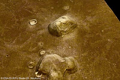
New Images of "Face on Mars"

The "Face on Mars" from a different angle
Image: esa.int

The European Space Agency (ESA) is collecting Martian geologic data. The ESA's Mars Express spacecraft has captured images of Mar's Cydonia region, the location of the famous "Face on Mars." The new photos reveal what scientists had originally thought--the "Face" is an illusion caused by light and shadow. The Cydonia region is located at 40.75° North and 350.54° East on the Martian surface. Nasa's famous image was taken on July 25, 1976 by the Viking 1 Orbiter.

Labels: , ,